It’s that time of year again.
It’s Storm season on the prairies. This week is shaping up to be a great week for storm development. The main tornadic threat will be on the East side of the province into Manitoba on Thursday and Friday. I suspect early this afternoon watches will start going up.
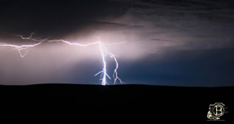
Last night brought heavy lightning to the area. This photo was taken SW of Eatonia at 12:15 am June 8th:
So with the threat of possible strong storms rolling through over the week its time to remind everybody of a few safety tips regarding severe weather. In this case do as I say not as I do. You can follow me on twitter for up dates for severe weather when I’m in the field @JennyLeeHagan
Source: ec.gc.ca/meteo-weather
Planning Ahead
Having a storm readiness plan in place saves valuable time if severe weather strikes. Take the opportunity now to choose the best shelter in your home and office, and make sure all concerned know where it is. Choose a meeting place to gather after the storm to ensure that everyone is safe and accounted for.
Maintain an emergency pack with a battery-powered flashlight, a radio (with Weatheradio capability preferably), tools for emergency repair, food supplies, a first aid kit, blankets and extra clothing. Keep your car gas tank full, in case gas stations close down after a storm. When a warning is issued, stay calm and follow your plan.
Taking Shelter
When there is a threat of high winds, as in the case of a severe thunderstorm or tornado, your first priority is to take shelter. If it is safe to do so, bring livestock and/or pets indoors, close all windows and doors, and secure loose outdoor objects or move them inside.
Go to the basement or to a small interior room in the centre of the house, such as a closet, bathroom or hallway, on the lowest floor of the building. If this is not an option, take cover under a stairway or sturdy table and use a cushion or mattress to protect your head. Stay away from all windows, doors and exterior walls, in particular those facing the storm, and avoid buildings with large, unsupported roofs such as arenas, supermarkets, and barns. If you are boating or swimming, head for land immediately.
Do not travel. If you are in your car, open the windows slightly and park off the road with your brakes set, away from tall objects and power lines. Do not leave your car if there are downed lines nearby. In the event of a tornado, abandon your vehicle and move at a right angle to the storm’s path. If this is not possible, find a low-lying area, such as a ditch, and lie flat. Hang onto a small tree or shrub if you can.
Lightning – When thunder roars, GO INDOORS!
Lightning is an electrical discharge caused by a build up of static electricity between thunderclouds, or between thunderclouds and the ground. It can deliver as much as 100 million volts of electricity and strike a target up to 16 kilometres away, making it an extremely dangerous form of severe weather.
Thunder is the noise created when air suddenly expands from the heat of a lightning discharge. If you count the seconds between a flash of lightning and a thunder clap, you can tell approximately how close the lightning is to you: each second representing about 300 metres.
Lightning Safety
Each year lightning kills approximately 10 Canadians and injures approximately 100 to 150 others. So, how do you keep yourself and your family safe when lightning strikes? Read the tips and information below and stay safe!
The first and most important thing to remember is that if you can hear thunder, you are within striking distance of lightning. Take shelter immediately. If you cannot find a sturdy, fully enclosed building with wiring and plumbing, get into a metal-roofed vehicle. Stay inside for 30 minutes after the last rumble of thunder.
Once indoors, stay away from electrical appliances and equipment, doors, windows, fireplaces, and anything else that will conduct electricity, such as sinks, tubs and showers. Avoid using a telephone that is connected to a landline.
If you are in your car during lightning, do not park under tall objects that could topple, and do not get out if there are downed power lines nearby.
If you are caught outside, don’t stand near tall objects or anything made of metal, and avoid open water. Take shelter in a low lying area.
If caught on the water in a small boat with no cabin during thunder and lightning, quickly get to shore. Boats with cabins offer a safer environment, but it’s still not ideal.
Remember, there is no safe place outdoors during a thunderstorm. Once in a safe location, remain there for 30 minutes after the last rumble of thunder is heard before resuming your outdoor activities.
People who have been struck by lightning do not carry an electrical charge and can be safely handled, but victims may be suffering from burns or shock and should receive medical attention immediately. If you come across someone who has been struck, call for medical assistance immediately and, if breathing has stopped, administer mouth-to-mouth or cardio-pulmonary resuscitation (CPR).
Rain – Long or short duration, it can add up!
Two types of summer heavy rains:
- Large scale weather systems with long-term rainfall –
- These large weather systems can last several days. Environment Canada issues Rainfall Warnings for this type of event.
- Short-lived thunderstorms with significant rainfall –
- Within a short period of time, sometimes only minutes, localized downpours from thunderstorms can produce flash flooding. Environment Canada issues Severe Thunderstorm Warnings for these types of rainfall events.
Heavy Rain Safety:
- Routinely monitor the Environment Canada weather forecasts for watches and warnings of potential heavy rains or severe thunderstorms with local heavy downpours.
- Know potential risks for flooding in your area and plan an escape route to higher ground but keep in mind the threat from lightning which is greater on high ground.
- During heavy rains, avoid roadway underpasses, drainage ditches, low lying areas and water collection areas. They can unexpectedly flood or overflow. DO NOT TRY TO DRIVE ACROSS A FLOODED ROAD. You can’t tell the condition of the road under the water.
- Stay away from power lines or electrical wires during floods.
Monitor the provincial government flood forecasts and warnings.
Floods
Most flooding occurs when the volume of water in a river or stream exceeds the capacity of the channel. Flooding also takes place along lake and coastal shorelines, when higher than normal water levels inundate low-lying areas.
Numerous factors affect streamflow, and therefore the potential for flooding. Most important are the amount and type of precipitation, the nature and condition of the drainage basin, and climate.
Flooding is essential to a healthy environment, but can cause human hardship and economic loss.
Thunderstorm “Straight-Line” Winds
More common and dangerous than you may realize
Across much of Canada, “straight-line” winds (not tornadoes) cause most thunderstorm wind damage. Straight-line winds are winds that move horizontally along the ground away from thunderstorms, sometimes with tornado-like force. These strong winds may be technically labelled as microbursts, downbursts, squall lines, plough winds or derechoes and may cause swirling dust and debris often confused with tornadoes.
Just like with tornadoes, straight-line winds are capable of causing damage such as blowing down trees or buildings. Roofing debris, tree branches, or unsecured construction materials blowing in a storm may become lethal projectiles and can cause significant damage if they hit something. Wind-driven rain or large hail may follow the strong winds and hide potentially dangerous or deadly flying debris.
Straight-line winds may produce the same roar like a freight train noise often associated with tornadoes.
Wind Safety:
- Stay alert … the tendency is to hunch over and look down when facing strong wind, you may not see a wind projectile approaching.
- Listen for Environment Canada warnings of all types.
- Watch for signs of wind in the sky …
- swirls of dust on the ground or approaching waves on water
- shelf clouds beneath thunderstorms are often associated with strong gusty winds.
Seek shelter, preferably indoors away from outside walls especially large glass surfaces. Avoid large open spans in buildings such as gymnasiums or malls.
Wind
A strong wind does not only occur on a large scale from tropical storms or low pressure systems and fronts, but also on a small scale, from thunderstorms, Chinooks or the local geography.
Strong winds, and especially gusty winds, can cause property damage or turn any loose item into a dangerous projectile, and create unsafe travelling conditions that affect your ability to safely steer your car.
When there is a wind warning for your area, you should expect inland winds to be blowing steadily at 60-65 km/h or more, or winds that are gusting up to 90 km/h or more. Secure or put away loose objects such as outdoor furniture or garbage cans, put your car in the garage, and bring livestock to shelter.
Safety Tips: High wind in combination with heavy rain can increase the risk of tree limb breakage or trees uprooting. After heavy winds, check your property for dead branches and damage. With winds between 60 and 70 km/h, you will have difficulty with balance and walking against the wind. Twigs and small branches could also blow off trees and cause a hazard, so stay inside until it is safe.
Tornado – Nature’s dangerous wonder
A tornado is a violently rotating column of air extending between a cloud base and the surface (when over water, it is called a waterspout). While often depicted as a funnel with the narrow end on the bottom, there is no typical tornado. Tornadoes exhibit a high degree of variability in their appearance, strength, speed, direction of movement, and duration.
Most tornadoes develop in the late afternoon and early evening but may occur outside of this timeframe, including overnight.
While wide, damaging, straight-line thunderstorm winds are often confused with tornadoes, tornadoes can produce some of the highest wind speeds on the planet. The majority of Canadian tornadoes have maximum wind speeds under 180 km/h, but a small percentage can be considerably stronger with devastating impacts. Although Doppler radar is a major aid to weather forecasters in the prediction of larger tornadoes, many smaller ones are very difficult to forecast.
Tornado Safety:
Monitor Environment Canada watches and warnings and keep an eye on the sky – tornadoes can develop very rapidly.
- When a tornado threatens, take shelter immediately – preferably in the lower level of a sturdy building. Mobile home residents should go to their shelter area.
- Flying glass and other debris pose the greatest danger to human safety.
- If caught outdoors with no shelter available, lie flat in a ditch, ravine or other low lying area and shield your head with your arms.
Recent research has shown that tornado winds finding their way into a building through open doors and windows can lead to large internal pressures and greater damage. When a watch is issued, that is the time to ensure that all doors and windows are closed.
Hail – Don’t let it put a dent in your plans!
Hail is formed when updrafts in thunderclouds carry raindrops upward into extremely cold areas of the atmosphere, where they freeze and merge into lumps of ice. When the lumps become too heavy to be supported by the updraft, they fall to the ground at speeds of up to 100 km/h or more.
Hailstones as large as grapefruit have been reported in Canada, but even smaller hail can be dangerous and can cause extensive damage in a matter of minutes.
The Prairies are especially vulnerable to hail, receiving more severe hail events and more damage to crops and personal property than from all other summer severe weather events combined including tornadoes, severe thunderstorm winds and heavy rains. Ontario is the other hail-prone area of Canada with over one quarter of the summer severe weather events due to hail.
Hail Safety:
- Routinely monitor the Environment Canada weather forecasts, watches and warnings for thunderstorms (which may include hail).
- When hail or thunderstorms threaten, seek shelter in a solid building and stay away from windows, glass doors or skylights.
- If you are in a vehicle, find a place to safely pull off roadways and protect yourself from possible shattered glass.
- If caught outdoors and there is no available shelter, crouch down, face away from the wind and protect your head and neck with your hands.
- Look out for flooded areas. Excessive hail (when combined with heavy rain) can plug storm drains and suddenly create local flooding.
Remember the danger of lightning. When outside stay away from tall objects such as large trees, towers, metal fences or poles.