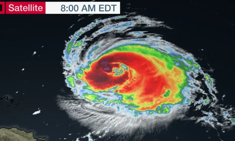
Lee, a formidable and sizable hurricane, is poised to shift its trajectory northward in the middle of the week. The precise path it takes will dictate where its effects, including rain, wind, and coastal flooding, will be felt. This includes the potential for impact on Bermuda, sections of New England, and Atlantic Canada.
Irrespective of Hurricane Lee’s exact route, there will be the propagation of rip currents and high surf from the Southeastern coast, extending northward along a significant portion of the East Coast in the coming days.
The latest information on Lee reveals it to be a robust hurricane situated approximately 575 miles south of Bermuda, moving in a west-northwest direction. As of Tuesday morning, Lee maintains its status as a major Category 3 hurricane.
Hurricane-force winds extend up to 80 miles from its center, while tropical-storm-force winds reach out to 185 miles.
Over the next five days, Lee is projected to turn northward during the middle of the week, continuing on this northerly course into the weekend. Its intensity may fluctuate through midweek, but it is expected to weaken as it heads northward, encountering cooler water temperatures, dry air, higher wind shear, and influences from Hurricane Franklin and the remnants of Idalia.
Even though the hurricane is anticipated to weaken, its wind field is expected to expand, leading to impacts over a broader area.
The exact northward path of Lee will determine its impact on Bermuda, Atlantic Canada, and New England. Presently, Lee is being guided west-northwestward by a high-pressure system to its north. However, a northward shift will be induced by a dip in the jet stream moving into the eastern U.S. during midweek.
The precise location of this turn and how Lee interacts with the jet stream remain uncertain factors, contributing to a wider range of computer model predictions in the latter part of the week.
The storm is also anticipated to increase in size, potentially extending its impacts well beyond its center.
Given these considerations, here is a general overview of the expected impacts:
- Bermuda: Anticipate rainfall, tropical-storm-force winds, and high surf by Thursday.
- Atlantic Canada: Nova Scotia and New Brunswick may experience heavy rain, strong winds, high surf, and coastal flooding by Friday night or Saturday.
- Eastern New England: Rain and wind effects are expected by late Friday or Saturday, with the intensity depending on Lee’s precise path. A more westerly track would bring stronger winds and heavier rainfall, while an easterly track would reduce rainfall but still bring gusty winds. Coastal areas are likely to face high surf and potential coastal flooding, regardless of Lee’s path.
Residents and interests in these areas should closely monitor Lee’s forecast, acknowledging that hurricane forecasts are subject to change. Stay updated for the latest information on this and other developing storms in the 2023 hurricane season.
One certainty, regardless of Lee’s track, is the generation of hazardous conditions along the Eastern Seaboard this week, including dangerous high surf, rip currents, coastal flooding, and beach erosion. This applies particularly to the region spanning from the Southeastern U.S. to New England.
Due to the storm’s initial slow movement and increased size, coastal flooding is likely to persist over multiple days and tide cycles. Those living near or planning to visit Atlantic beaches should exercise caution, especially if red flags are posted at the beach.
Lee’s History So Far:
Lee became the 13th storm of the 2023 Atlantic hurricane season on Tuesday afternoon and transformed into the fourth hurricane of the season by late Wednesday afternoon, surpassing the typical pace of the fourth hurricane occurrence by over a week (which typically happens around September 16, according to National Hurricane Center data).
Lee then underwent a remarkable rapid intensification, elevating from a Category 1 to a Category 5 hurricane in just 18 hours on Thursday. Since 1982, only three other Atlantic hurricanes have seen such rapid wind increases of 80 mph or more in 24 hours or less, most recently Matthew in 2016. This was the swiftest 24-hour intensification recorded in the Atlantic Basin outside the Gulf of Mexico and Caribbean Sea in 41 years, according to Kieran Bhatia, a scientist at Princeton University.
Hurricane reconnaissance recorded sustained winds of 160 mph on Thursday evening, making Lee the first Category 5 hurricane since Ian in 2022. Before Lee, only 39 other Atlantic hurricanes achieved Category 5 intensity over the past century.
Lee rapidly weakened to a Category 2 on Saturday due to increased wind shear, but it regained strength late Sunday and returned to Category 3 status.


